
Magnitude 4.9 - TONGA
2011 January 06 20:57:11 UTC
Earthquake Details
- This event has been reviewed by a seismologist.
| Magnitude | 4.9 |
|---|---|
| Date-Time |
|
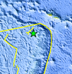
| Location | 15.668°S, 174.313°W |
| Depth | 130.5 km (81.1 miles) |
| Region | TONGA |
| Distances | 70 km (40 miles) WNW of Hihifo, Tonga 330 km (205 miles) SE of MATA'UTU, Ile Uvea, Wallis and Futuna 610 km (380 miles) N of NUKU`ALOFA, Tonga 2580 km (1600 miles) NNE of Auckland, New Zealand |
| Location Uncertainty | horizontal +/- 30.8 km (19.1 miles); depth +/- 4.9 km (3.0 miles) |
| Parameters | NST= 30, Nph= 30, Dmin=335.1 km, Rmss=0.96 sec, Gp=130°, M-type=body wave magnitude (Mb), Version=5 |
| Source |
|
| Event ID | usc0000zy1 |
- Did you feel it? Report shaking and damage at your location. You can also view a map displaying accumulated data from your report and others.
Earthquake Maps


Scientific & Technical Information
 Historic Moment Tensor Solutions
- Preliminary Earthquake Report
- U.S. Geological Survey, National Earthquake Information Center:
World Data Center for Seismology, Denver
