
Magnitude 4.5 - BISMARCK SEA
2011 January 04 11:31:53 UTC
Earthquake Details
- This event has been reviewed by a seismologist.
| Magnitude | 4.5 |
|---|---|
| Date-Time |
|
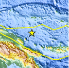
| Location | 3.916°S, 146.689°E |
| Depth | 34.9 km (21.7 miles) set by location program |
| Region | BISMARCK SEA |
| Distances | 175 km (110 miles) NE of Madang, New Guinea, PNG 220 km (135 miles) SSW of Lorengau, Manus Island, PNG 615 km (380 miles) N of PORT MORESBY, Papua New Guinea 2700 km (1670 miles) NNW of BRISBANE, Queensland, Australia |
| Location Uncertainty | horizontal +/- 25.9 km (16.1 miles); depth fixed by location program |
| Parameters | NST= 12, Nph= 12, Dmin=220.4 km, Rmss=0.43 sec, Gp=126°, M-type=body wave magnitude (Mb), Version=2 |
| Source |
|
| Event ID | usc0000yqd |
- Did you feel it? Report shaking and damage at your location. You can also view a map displaying accumulated data from your report and others.

Earthquake Maps


Scientific & Technical Information
 Historic Moment Tensor Solutions
- Preliminary Earthquake Report
- U.S. Geological Survey, National Earthquake Information Center:
World Data Center for Seismology, Denver
