
Magnitude 4.7 - VANUATU
2010 November 27 10:49:45 UTC
Earthquake Details
- This event has been reviewed by a seismologist.
| Magnitude | 4.7 |
|---|---|
| Date-Time |
|
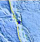
| Location | 16.275°S, 167.814°E |
| Depth | 220.5 km (137.0 miles) |
| Region | VANUATU |
| Distances | 105 km (65 miles) SE of Luganville, Espiritu Santo, Vanuatu 170 km (105 miles) NNW of PORT-VILA, Efate, Vanuatu 395 km (245 miles) NNW of Isangel, Tanna, Vanuatu 1965 km (1220 miles) NE of BRISBANE, Queensland, Australia |
| Location Uncertainty | horizontal +/- 24.6 km (15.3 miles); depth +/- 3.9 km (2.4 miles) |
| Parameters | NST= 21, Nph= 23, Dmin=>999 km, Rmss=0.8 sec, Gp= 83°, M-type=body wave magnitude (Mb), Version=4 |
| Source |
|
| Event ID | usc0000gdl |
- Did you feel it? Report shaking and damage at your location. You can also view a map displaying accumulated data from your report and others.
Earthquake Maps


Scientific & Technical Information
 Historic Moment Tensor Solutions
- Preliminary Earthquake Report
- U.S. Geological Survey, National Earthquake Information Center:
World Data Center for Seismology, Denver
