
Magnitude 4.8 - SOUTH OF THE FIJI ISLANDS
2010 November 27 05:53:15 UTC
Earthquake Details
- This event has been reviewed by a seismologist.
| Magnitude | 4.8 |
|---|---|
| Date-Time |
|
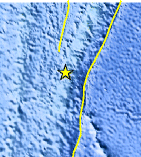
| Location | 23.709°S, 176.314°W |
| Depth | 55.7 km (34.6 miles) |
| Region | SOUTH OF THE FIJI ISLANDS |
| Distances |
|
| Location Uncertainty | horizontal +/- 22.8 km (14.2 miles); depth +/- 0.8 km (0.5 miles) |
| Parameters | NST= 46, Nph= 48, Dmin=883.9 km, Rmss=1.52 sec, Gp= 94°, M-type=body wave magnitude (Mb), Version=5 |
| Source |
|
| Event ID | usc0000gcp |
- Did you feel it? Report shaking and damage at your location. You can also view a map displaying accumulated data from your report and others.
Earthquake Maps


Scientific & Technical Information
 Historic Moment Tensor Solutions
- Preliminary Earthquake Report
- U.S. Geological Survey, National Earthquake Information Center:
World Data Center for Seismology, Denver
