
Magnitude 4.4 - CERAM SEA, INDONESIA
2010 November 26 20:04:24 UTC
Earthquake Details
- This event has been reviewed by a seismologist.
| Magnitude | 4.4 |
|---|---|
| Date-Time |
|
| Location | 3.541°S, 131.156°E |
| Depth | 10 km (6.2 miles) set by location program |
| Region | CERAM SEA, INDONESIA |
| Distances | 295 km (185 miles) S of Sorong, Papua, Indonesia 330 km (205 miles) E of Ambon, Moluccas, Indonesia 990 km (610 miles) N of DARWIN, Northern Territory, Australia 2715 km (1680 miles) E of JAKARTA, Java, Indonesia |
| Location Uncertainty | horizontal +/- 11.3 km (7.0 miles); depth fixed by location program |
| Parameters | NST= 35, Nph= 35, Dmin=139.6 km, Rmss=1.56 sec, Gp= 68°, M-type=body wave magnitude (Mb), Version=7 |
| Source |
|
| Event ID | usc0000g9i |
- Did you feel it? Report shaking and damage at your location. You can also view a map displaying accumulated data from your report and others.
Earthquake Maps

Earthquake Location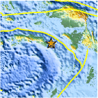
Location Maps
Historical Seismicity
Seismic Hazard Map
EQ Density Map
Google Map
Google Earth KML
(Requires Google Earth)- Did you feel it? Report shaking and damage at your location. You can also view a map displaying accumulated data from your report and others.
Scientific & Technical Information
 Historic Moment Tensor Solutions
- Preliminary Earthquake Report
- U.S. Geological Survey, National Earthquake Information Center:
World Data Center for Seismology, Denver
