
Magnitude 4.7 - CERAM SEA, INDONESIA
2010 November 26 20:09:19 UTC
Earthquake Details
- This event has been reviewed by a seismologist.
| Magnitude | 4.7 |
|---|---|
| Date-Time |
|
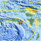
| Location | 3.369°S, 131.064°E |
| Depth | 5 km (3.1 miles) (poorly constrained) |
| Region | CERAM SEA, INDONESIA |
| Distances | 275 km (170 miles) S of Sorong, Papua, Indonesia 320 km (200 miles) E of Ambon, Moluccas, Indonesia 1005 km (620 miles) N of DARWIN, Northern Territory, Australia 2700 km (1680 miles) E of JAKARTA, Java, Indonesia |
| Location Uncertainty | horizontal +/- 9.7 km (6.0 miles); depth +/- 35.4 km (22.0 miles) |
| Parameters | NST= 42, Nph= 42, Dmin=140.8 km, Rmss=1.35 sec, Gp= 61°, M-type=body wave magnitude (Mb), Version=7 |
| Source |
|
| Event ID | usc0000g99 |
- Did you feel it? Report shaking and damage at your location. You can also view a map displaying accumulated data from your report and others.

Earthquake Maps


Scientific & Technical Information
 Historic Moment Tensor Solutions
- Preliminary Earthquake Report
- U.S. Geological Survey, National Earthquake Information Center:
World Data Center for Seismology, Denver
