
Magnitude 5.0 - SOUTHEAST OF THE LOYALTY ISLANDS
2010 November 25 16:15:33 UTC
Earthquake Details
- This event has been reviewed by a seismologist.
| Magnitude | 5.0 |
|---|---|
| Date-Time |
|
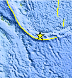
| Location | 22.750°S, 171.444°E |
| Depth | 58.3 km (36.2 miles) |
| Region | SOUTHEAST OF THE LOYALTY ISLANDS |
| Distances | 75 km (45 miles) WSW of Ile Hunter, Loyalty Isl., New Caledonia 340 km (210 miles) WSW of Ceva-i-Ra, Fiji 515 km (320 miles) E of NOUMEA, New Caledonia 1590 km (990 miles) NNW of Auckland, New Zealand |
| Location Uncertainty | horizontal +/- 7.6 km (4.7 miles); depth +/- 13.5 km (8.4 miles) |
| Parameters | NST= 61, Nph= 61, Dmin=520.5 km, Rmss=0.96 sec, Gp=112°, M-type=body wave magnitude (Mb), Version=7 |
| Source |
|
| Event ID | usc0000g0g |
- Did you feel it? Report shaking and damage at your location. You can also view a map displaying accumulated data from your report and others.
Earthquake Maps


Scientific & Technical Information
 Historic Moment Tensor Solutions
 Tsunami Information
The earthquake locations and magnitudes cited in NOAA tsunami statements and bulletins are preliminary and are superseded by USGS locations and magnitudes computed using more extensive data sets.
NOAA Tsunami Bulletins for this Earthquake
No Bulletins have been issued at this time.
General Tsunami Information
- Preliminary Earthquake Report
- U.S. Geological Survey, National Earthquake Information Center:
World Data Center for Seismology, Denver
