
Magnitude 4.7 - NORTHERN SUMATRA, INDONESIA
2010 November 25 07:00:49 UTC
Earthquake Details
- This event has been reviewed by a seismologist.
| Magnitude | 4.7 |
|---|---|
| Date-Time |
|
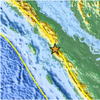
| Location | 1.063°N, 99.367°E |
| Depth | 14.2 km (8.8 miles) |
| Region | NORTHERN SUMATRA, INDONESIA |
| Distances | 35 km (25 miles) SSE of Padangsidempuan, Sumatra, Indonesia 100 km (60 miles) SE of Sibolga, Sumatra, Indonesia 350 km (215 miles) SW of KUALA LUMPUR, Malaysia 1155 km (710 miles) NW of JAKARTA, Java, Indonesia |
| Location Uncertainty | horizontal +/- 21.3 km (13.2 miles); depth +/- 4.9 km (3.0 miles) |
| Parameters | NST= 18, Nph= 18, Dmin=187 km, Rmss=1.21 sec, Gp=166°, M-type=body wave magnitude (Mb), Version=4 |
| Source |
|
| Event ID | usc0000fws |
- Did you feel it? Report shaking and damage at your location. You can also view a map displaying accumulated data from your report and others.

Earthquake Maps


Scientific & Technical Information
 Historic Moment Tensor Solutions
- Preliminary Earthquake Report
- U.S. Geological Survey, National Earthquake Information Center:
World Data Center for Seismology, Denver
