
Magnitude 5.1 - SOUTH OF THE FIJI ISLANDS
2010 November 24 18:35:53 UTC
Earthquake Details
- This event has been reviewed by a seismologist.
| Magnitude | 5.1 |
|---|---|
| Date-Time |
|
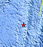
| Location | 24.348°S, 179.618°W |
| Depth | 530.4 km (329.6 miles) |
| Region | SOUTH OF THE FIJI ISLANDS |
| Distances | 420 km (260 miles) SSW of Ndoi Island, Fiji 570 km (355 miles) NNW of Raoul Island, Kermadec Islands 715 km (445 miles) SSE of SUVA, Viti Levu, Fiji 1485 km (920 miles) NNE of Auckland, New Zealand |
| Location Uncertainty | horizontal +/- 30.3 km (18.8 miles); depth +/- 26.4 km (16.4 miles) |
| Parameters | NST= 31, Nph= 36, Dmin=568.8 km, Rmss=1.05 sec, Gp=126°, M-type=body wave magnitude (Mb), Version=4 |
| Source |
|
| Event ID | usc0000fld |
- Did you feel it? Report shaking and damage at your location. You can also view a map displaying accumulated data from your report and others.
Earthquake Maps


Scientific & Technical Information
 Historic Moment Tensor Solutions
 Tsunami Information
The earthquake locations and magnitudes cited in NOAA tsunami statements and bulletins are preliminary and are superseded by USGS locations and magnitudes computed using more extensive data sets.
NOAA Tsunami Bulletins for this Earthquake
No Bulletins have been issued at this time.
General Tsunami Information
- Preliminary Earthquake Report
- U.S. Geological Survey, National Earthquake Information Center:
World Data Center for Seismology, Denver
