
Magnitude 5.0 - BANDA SEA
2010 November 24 08:38:28 UTC
Earthquake Details
- This event has been reviewed by a seismologist.
| Magnitude | 5.0 |
|---|---|
| Date-Time |
|
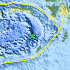
| Location | 6.166°S, 130.636°E |
| Depth | 125.4 km (77.9 miles) |
| Region | BANDA SEA |
| Distances | 210 km (130 miles) NNW of Saumlaki, Kepulauan Tanimbar, Indonesia 385 km (240 miles) SE of Ambon, Moluccas, Indonesia 695 km (430 miles) N of DARWIN, Northern Territory, Australia 2625 km (1630 miles) E of JAKARTA, Java, Indonesia |
| Location Uncertainty | horizontal +/- 20.2 km (12.6 miles); depth +/- 11.2 km (7.0 miles) |
| Parameters | NST= 35, Nph= 39, Dmin=213.7 km, Rmss=1.06 sec, Gp= 76°, M-type=body wave magnitude (Mb), Version=4 |
| Source |
|
| Event ID | usc0000fh8 |
- Did you feel it? Report shaking and damage at your location. You can also view a map displaying accumulated data from your report and others.

Earthquake Maps


Scientific & Technical Information
 Historic Moment Tensor Solutions
 Tsunami Information
The earthquake locations and magnitudes cited in NOAA tsunami statements and bulletins are preliminary and are superseded by USGS locations and magnitudes computed using more extensive data sets.
NOAA Tsunami Bulletins for this Earthquake
No Bulletins have been issued at this time.
General Tsunami Information
- Preliminary Earthquake Report
- U.S. Geological Survey, National Earthquake Information Center:
World Data Center for Seismology, Denver
