
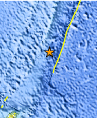
Magnitude 5.9 - SOUTH OF THE KERMADEC ISLANDS
2010 November 22 16:18:43 UTC
Earthquake Details
- This event has been reviewed by a seismologist.
| Magnitude | 5.9 |
|---|---|
| Date-Time |
|
| Location | 33.636°S, 178.930°W |
| Depth | 10 km (6.2 miles) set by location program |
| Region | SOUTH OF THE KERMADEC ISLANDS |
| Distances | 245 km (150 miles) S of L'Esperance Rock, Kermadec Islands 495 km (305 miles) S of Raoul Island, Kermadec Islands 675 km (420 miles) ENE of Auckland, New Zealand 1020 km (630 miles) NE of WELLINGTON, New Zealand |
| Location Uncertainty | horizontal +/- 8.5 km (5.3 miles); depth fixed by location program |
| Parameters | NST=109, Nph=109, Dmin=625.8 km, Rmss=1.12 sec, Gp= 58°, M-type=centroid moment magnitude (Mw), Version=R |
| Source |
|
| Event ID | usc0000el4 |
- Did you feel it? Report shaking and damage at your location. You can also view a map displaying accumulated data from your report and others.
Earthquake Maps


Scientific & Technical Information

 Tsunami Information
The earthquake locations and magnitudes cited in NOAA tsunami statements and bulletins are preliminary and are superseded by USGS locations and magnitudes computed using more extensive data sets.
NOAA Tsunami Bulletins for this Earthquake
No Bulletins have been issued at this time.
General Tsunami Information
- Preliminary Earthquake Report
- U.S. Geological Survey, National Earthquake Information Center:
World Data Center for Seismology, Denver
