
Magnitude 4.7 - FIJI REGION
2010 November 22 14:40:55 UTC
Earthquake Details
- This event has been reviewed by a seismologist.
| Magnitude | 4.7 |
|---|---|
| Date-Time |
|
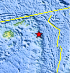
| Location | 17.843°S, 178.557°W |
| Depth | 583 km (362.3 miles) |
| Region | FIJI REGION |
| Distances | 270 km (170 miles) SE of Lambasa, Vanua Levu, Fiji 310 km (195 miles) N of Ndoi Island, Fiji 320 km (200 miles) E of SUVA, Viti Levu, Fiji 2205 km (1370 miles) NNE of Auckland, New Zealand |
| Location Uncertainty | horizontal +/- 14.6 km (9.1 miles); depth +/- 9.5 km (5.9 miles) |
| Parameters | NST=118, Nph=118, Dmin=360 km, Rmss=0.8 sec, Gp=130°, M-type=body wave magnitude (Mb), Version=7 |
| Source |
|
| Event ID | usc0000ek3 |
- Did you feel it? Report shaking and damage at your location. You can also view a map displaying accumulated data from your report and others.
Earthquake Maps


Scientific & Technical Information
 Historic Moment Tensor Solutions
- Preliminary Earthquake Report
- U.S. Geological Survey, National Earthquake Information Center:
World Data Center for Seismology, Denver
