
Magnitude 4.6 - FIJI REGION
2010 November 21 03:33:16 UTC
Earthquake Details
- This event has been reviewed by a seismologist.
| Magnitude | 4.6 |
|---|---|
| Date-Time |
|
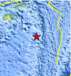
| Location | 19.912°S, 178.868°W |
| Depth | 578.6 km (359.5 miles) |
| Region | FIJI REGION |
| Distances | 85 km (50 miles) NNW of Ndoi Island, Fiji 345 km (215 miles) SE of SUVA, Viti Levu, Fiji 405 km (250 miles) WNW of NUKU`ALOFA, Tonga 1980 km (1230 miles) NNE of Auckland, New Zealand |
| Location Uncertainty | horizontal +/- 71.5 km (44.4 miles); depth +/- 11.3 km (7.0 miles) |
| Parameters | NST= 23, Nph= 23, Dmin=404.1 km, Rmss=0.44 sec, Gp=198°, M-type=body wave magnitude (Mb), Version=5 |
| Source |
|
| Event ID | usc0000e0x |
- Did you feel it? Report shaking and damage at your location. You can also view a map displaying accumulated data from your report and others.
Earthquake Maps


Scientific & Technical Information
 Historic Moment Tensor Solutions
- Preliminary Earthquake Report
- U.S. Geological Survey, National Earthquake Information Center:
World Data Center for Seismology, Denver
