
Magnitude 5.2 - VANUATU
2010 November 20 06:12:03 UTC
Earthquake Details
- This event has been reviewed by a seismologist.
| Magnitude | 5.2 |
|---|---|
| Date-Time |
|
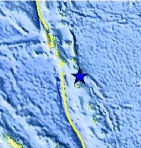
| Location | 17.174°S, 168.491°E |
| Depth | 231.7 km (144.0 miles) |
| Region | VANUATU |
| Distances | 65 km (40 miles) NNE of PORT-VILA, Efate, Vanuatu 230 km (145 miles) SE of Luganville, Espiritu Santo, Vanuatu 275 km (170 miles) NNW of Isangel, Tanna, Vanuatu 1950 km (1220 miles) ENE of BRISBANE, Queensland, Australia |
| Location Uncertainty | horizontal +/- 16.9 km (10.5 miles); depth +/- 1.8 km (1.1 miles) |
| Parameters | NST=368, Nph=371, Dmin=>999 km, Rmss=0.8 sec, Gp= 29°, M-type=body wave magnitude (Mb), Version=9 |
| Source |
|
| Event ID | usc0000dnn |
- Did you feel it? Report shaking and damage at your location. You can also view a map displaying accumulated data from your report and others.
Earthquake Maps


Scientific & Technical Information
 Historic Moment Tensor Solutions
 Tsunami Information
The earthquake locations and magnitudes cited in NOAA tsunami statements and bulletins are preliminary and are superseded by USGS locations and magnitudes computed using more extensive data sets.
NOAA Tsunami Bulletins for this Earthquake
No Bulletins have been issued at this time.
General Tsunami Information
- Preliminary Earthquake Report
- U.S. Geological Survey, National Earthquake Information Center:
World Data Center for Seismology, Denver
