
Magnitude 4.8 - KEPULAUAN MENTAWAI REGION, INDONESIA
2010 November 20 02:13:34 UTC
Earthquake Details
- This event has been reviewed by a seismologist.
| Magnitude | 4.8 |
|---|---|
| Date-Time |
|
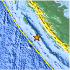
| Location | 3.297°S, 100.217°E |
| Depth | 11.9 km (7.4 miles) (poorly constrained) |
| Region | KEPULAUAN MENTAWAI REGION, INDONESIA |
| Distances | 235 km (145 miles) WNW of Bengkulu, Sumatra, Indonesia 260 km (160 miles) S of Padang, Sumatra, Indonesia 295 km (180 miles) W of Lubuklinggau, Sumatra, Indonesia 800 km (495 miles) WNW of JAKARTA, Java, Indonesia |
| Location Uncertainty | horizontal +/- 9.9 km (6.2 miles); depth +/- 25.6 km (15.9 miles) |
| Parameters | NST= 55, Nph= 55, Dmin=326.1 km, Rmss=0.89 sec, Gp=104°, M-type=body wave magnitude (Mb), Version=7 |
| Source |
|
| Event ID | usc0000dm3 |
- Did you feel it? Report shaking and damage at your location. You can also view a map displaying accumulated data from your report and others.

Earthquake Maps


Scientific & Technical Information
 Historic Moment Tensor Solutions
- Preliminary Earthquake Report
- U.S. Geological Survey, National Earthquake Information Center:
World Data Center for Seismology, Denver
