
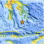
Magnitude 4.9 - FLORES SEA
2010 November 18 17:08:05 UTC
Earthquake Details
- This event has been reviewed by a seismologist.
| Magnitude | 4.9 |
|---|---|
| Date-Time |
|
| Location | 6.011°S, 122.058°E |
| Depth | 28.3 km (17.6 miles) |
| Region | FLORES SEA |
| Distances | 85 km (55 miles) SW of Baubau, Sulawesi, Indonesia 230 km (145 miles) SSW of Kendari, Sulawesi, Indonesia 1200 km (740 miles) NW of DARWIN, Northern Territory, Australia 1680 km (1050 miles) E of JAKARTA, Java, Indonesia |
| Location Uncertainty | horizontal +/- 21 km (13.0 miles); depth +/- 2.6 km (1.6 miles) |
| Parameters | NST= 45, Nph= 46, Dmin=278.3 km, Rmss=0.65 sec, Gp= 72°, M-type=body wave magnitude (Mb), Version=4 |
| Source |
|
| Event ID | usc0000cp7 |
- Did you feel it? Report shaking and damage at your location. You can also view a map displaying accumulated data from your report and others.

Earthquake Maps


Scientific & Technical Information
 Historic Moment Tensor Solutions
- Preliminary Earthquake Report
- U.S. Geological Survey, National Earthquake Information Center:
World Data Center for Seismology, Denver
