
Magnitude 5.8 - NEAR THE NORTH COAST OF PAPUA, INDONESIA
2010 November 16 01:39:41 UTC
Earthquake Details
- This event has been reviewed by a seismologist.
| Magnitude | 5.8 |
|---|---|
| Date-Time |
|
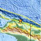
| Location | 2.010°S, 139.002°E |
| Depth | 5.1 km (3.2 miles) (poorly constrained) |
| Region | NEAR THE NORTH COAST OF PAPUA, INDONESIA |
| Distances | 200 km (125 miles) WNW of Jayapura, Papua, Indonesia 265 km (165 miles) WNW of Vanimo, New Guinea, PNG 1455 km (910 miles) NE of DARWIN, Northern Territory, Australia 3600 km (2230 miles) E of JAKARTA, Java, Indonesia |
| Location Uncertainty | horizontal +/- 4.3 km (2.7 miles); depth +/- 17.4 km (10.8 miles) |
| Parameters | NST=236, Nph=236, Dmin=757.8 km, Rmss=0.86 sec, Gp= 14°, M-type=body wave magnitude (Mb), Version=Q |
| Source |
|
| Event ID | usc0000bcw |
- Did you feel it? Report shaking and damage at your location. You can also view a map displaying accumulated data from your report and others.

Earthquake Maps


Scientific & Technical Information

 Tsunami Information
The earthquake locations and magnitudes cited in NOAA tsunami statements and bulletins are preliminary and are superseded by USGS locations and magnitudes computed using more extensive data sets.
NOAA Tsunami Bulletins for this Earthquake
No Bulletins have been issued at this time.
General Tsunami Information
- Preliminary Earthquake Report
- U.S. Geological Survey, National Earthquake Information Center:
World Data Center for Seismology, Denver
