
Magnitude 4.8 - NIAS REGION, INDONESIA
2010 November 15 09:43:24 UTC
Earthquake Details
- This event has been reviewed by a seismologist.
| Magnitude | 4.8 |
|---|---|
| Date-Time |
|
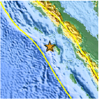
| Location | 1.241°N, 97.012°E |
| Depth | 30.5 km (19.0 miles) |
| Region | NIAS REGION, INDONESIA |
| Distances | 205 km (125 miles) WSW of Sibolga, Sumatra, Indonesia 250 km (155 miles) W of Padangsidempuan, Sumatra, Indonesia 565 km (350 miles) WSW of KUALA LUMPUR, Malaysia 1365 km (850 miles) NW of JAKARTA, Java, Indonesia |
| Location Uncertainty | horizontal +/- 26.3 km (16.3 miles); depth +/- 5.1 km (3.2 miles) |
| Parameters | NST= 40, Nph= 40, Dmin=266.1 km, Rmss=1.09 sec, Gp=122°, M-type=body wave magnitude (Mb), Version=4 |
| Source |
|
| Event ID | usc0000av2 |
- Did you feel it? Report shaking and damage at your location. You can also view a map displaying accumulated data from your report and others.

Earthquake Maps


Scientific & Technical Information
 Historic Moment Tensor Solutions
- Preliminary Earthquake Report
- U.S. Geological Survey, National Earthquake Information Center:
World Data Center for Seismology, Denver
