
Magnitude 4.6 - OFF THE WEST COAST OF NORTHERN SUMATRA
2010 November 14 09:45:19 UTC
Earthquake Details
- This event has been reviewed by a seismologist.
| Magnitude | 4.6 |
|---|---|
| Date-Time |
|
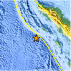
| Location | 1.656°N, 95.101°E |
| Depth | 29 km (18.0 miles) |
| Region | OFF THE WEST COAST OF NORTHERN SUMATRA |
| Distances | 410 km (255 miles) W of Sibolga, Sumatra, Indonesia 430 km (270 miles) S of Banda Aceh, Sumatra, Indonesia 750 km (465 miles) WSW of KUALA LUMPUR, Malaysia 1560 km (970 miles) WNW of JAKARTA, Java, Indonesia |
| Location Uncertainty | horizontal +/- 29 km (18.0 miles); depth +/- 3.6 km (2.2 miles) |
| Parameters | NST= 25, Nph= 27, Dmin=440.8 km, Rmss=0.74 sec, Gp=166°, M-type=body wave magnitude (Mb), Version=4 |
| Source |
|
| Event ID | usc0000af1 |
- Did you feel it? Report shaking and damage at your location. You can also view a map displaying accumulated data from your report and others.
Earthquake Maps


Scientific & Technical Information
 Historic Moment Tensor Solutions
- Preliminary Earthquake Report
- U.S. Geological Survey, National Earthquake Information Center:
World Data Center for Seismology, Denver
