
Magnitude 4.6 - BANDA SEA
2010 November 11 22:55:42 UTC
Earthquake Details
- This event has been reviewed by a seismologist.
| Magnitude | 4.6 |
|---|---|
| Date-Time |
|
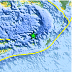
| Location | 6.965°S, 129.710°E |
| Depth | 138.3 km (85.9 miles) |
| Region | BANDA SEA |
| Distances |
|
| Location Uncertainty | horizontal +/- 17.7 km (11.0 miles); depth +/- 15.9 km (9.9 miles) |
| Parameters | NST= 34, Nph= 38, Dmin=208.2 km, Rmss=1.29 sec, Gp= 86°, M-type=body wave magnitude (Mb), Version=5 |
| Source |
|
| Event ID | usc00009gg |
- Did you feel it? Report shaking and damage at your location. You can also view a map displaying accumulated data from your report and others.

Earthquake Maps


Scientific & Technical Information
 Historic Moment Tensor Solutions
- Preliminary Earthquake Report
- U.S. Geological Survey, National Earthquake Information Center:
World Data Center for Seismology, Denver
