
Magnitude 5.2 - MOLUCCA SEA
2010 November 11 03:34:02 UTC
Earthquake Details
- This event has been reviewed by a seismologist.
| Magnitude | 5.2 |
|---|---|
| Date-Time |
|
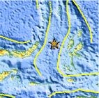
| Location | 1.460°N, 126.385°E |
| Depth | 14.1 km (8.8 miles) set by location program |
| Region | MOLUCCA SEA |
| Distances | 135 km (85 miles) NW of Ternate, Moluccas, Indonesia 170 km (105 miles) E of Manado, Sulawesi, Indonesia 1575 km (970 miles) SSE of MANILA, Philippines 2325 km (1450 miles) ENE of JAKARTA, Java, Indonesia |
| Location Uncertainty | horizontal +/- 19.1 km (11.9 miles); depth fixed by location program |
| Parameters | NST= 45, Nph= 46, Dmin=133.6 km, Rmss=1.02 sec, Gp=101°, M-type=body wave magnitude (Mb), Version=6 |
| Source |
|
| Event ID | usc0000925 |
- Did you feel it? Report shaking and damage at your location. You can also view a map displaying accumulated data from your report and others.

Earthquake Maps


Scientific & Technical Information
 Historic Moment Tensor Solutions
 Tsunami Information
The earthquake locations and magnitudes cited in NOAA tsunami statements and bulletins are preliminary and are superseded by USGS locations and magnitudes computed using more extensive data sets.
NOAA Tsunami Bulletins for this Earthquake
No Bulletins have been issued at this time.
General Tsunami Information
- Preliminary Earthquake Report
- U.S. Geological Survey, National Earthquake Information Center:
World Data Center for Seismology, Denver
