
Magnitude 5.2 - LUZON, PHILIPPINES
2010 November 10 10:30:20 UTC
Earthquake Details
- This event has been reviewed by a seismologist.
| Magnitude | 5.2 |
|---|---|
| Date-Time |
|
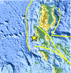
| Location | 14.956°N, 119.826°E |
| Depth | 59.2 km (36.8 miles) |
| Region | LUZON, PHILIPPINES |
| Distances | 45 km (30 miles) W of Olongapo, Luzon, Philippines 85 km (50 miles) WSW of Angeles, Luzon, Philippines 125 km (80 miles) WNW of MANILA, Philippines 135 km (85 miles) WSW of Cabanatuan, Luzon, Philippines |
| Location Uncertainty | horizontal +/- 16.5 km (10.3 miles); depth +/- 0.6 km (0.4 miles) |
| Parameters | NST= 83, Nph= 83, Dmin=295 km, Rmss=1.04 sec, Gp= 97°, M-type=body wave magnitude (Mb), Version=8 |
| Source |
|
| Event ID | usc00008kz |
- Did you feel it? Report shaking and damage at your location. You can also view a map displaying accumulated data from your report and others.

Earthquake Maps


Scientific & Technical Information

- Preliminary Earthquake Report
- U.S. Geological Survey, National Earthquake Information Center:
World Data Center for Seismology, Denver
