
Magnitude 5.2 - JAVA, INDONESIA
2010 November 09 12:38:59 UTC
Earthquake Details
- This event has been reviewed by a seismologist.
| Magnitude | 5.2 |
|---|---|
| Date-Time |
|
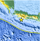
| Location | 7.885°S, 107.246°E |
| Depth | 69.7 km (43.3 miles) |
| Region | JAVA, INDONESIA |
| Distances | 115 km (70 miles) SSE of Sukabumi, Java, Indonesia 115 km (70 miles) SSW of Bandung, Java, Indonesia 125 km (75 miles) WSW of Tasikmalaya, Java, Indonesia 195 km (120 miles) SSE of JAKARTA, Java, Indonesia |
| Location Uncertainty | horizontal +/- 21.6 km (13.4 miles); depth +/- 7 km (4.3 miles) |
| Parameters | NST= 30, Nph= 32, Dmin=72.4 km, Rmss=1.28 sec, Gp=108°, M-type=body wave magnitude (Mb), Version=6 |
| Source |
|
| Event ID | usc000087d |
- Did you feel it? Report shaking and damage at your location. You can also view a map displaying accumulated data from your report and others.

Earthquake Maps


Scientific & Technical Information

 Tsunami Information
The earthquake locations and magnitudes cited in NOAA tsunami statements and bulletins are preliminary and are superseded by USGS locations and magnitudes computed using more extensive data sets.
NOAA Tsunami Bulletins for this Earthquake
No Bulletins have been issued at this time.
General Tsunami Information
- Preliminary Earthquake Report
- U.S. Geological Survey, National Earthquake Information Center:
World Data Center for Seismology, Denver
