
Magnitude 4.7 - SUMBA REGION, INDONESIA
2010 November 09 11:05:32 UTC
Earthquake Details
- This event has been reviewed by a seismologist.
| Magnitude | 4.7 |
|---|---|
| Date-Time |
|
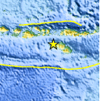
| Location | 9.549°S, 119.278°E |
| Depth | 60.1 km (37.3 miles) |
| Region | SUMBA REGION, INDONESIA |
| Distances | 110 km (70 miles) W of Waingapu, Sumba, Indonesia 135 km (85 miles) SSE of Bima, Sumbawa, Indonesia 270 km (170 miles) WSW of Ende, Flores, Indonesia 1425 km (880 miles) ESE of JAKARTA, Java, Indonesia |
| Location Uncertainty | horizontal +/- 19.3 km (12.0 miles); depth +/- 13.5 km (8.4 miles) |
| Parameters | NST= 22, Nph= 22, Dmin=340.6 km, Rmss=1.44 sec, Gp=101°, M-type=body wave magnitude (Mb), Version=5 |
| Source |
|
| Event ID | usc0000870 |
- Did you feel it? Report shaking and damage at your location. You can also view a map displaying accumulated data from your report and others.

Earthquake Maps


Scientific & Technical Information
 Historic Moment Tensor Solutions
- Preliminary Earthquake Report
- U.S. Geological Survey, National Earthquake Information Center:
World Data Center for Seismology, Denver
