
Magnitude 4.7 - D'ENTRECASTEAUX ISLANDS REGION
2010 November 08 23:48:26 UTC
Earthquake Details
- This event has been reviewed by a seismologist.
| Magnitude | 4.7 |
|---|---|
| Date-Time |
|
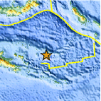
| Location | 9.400°S, 152.668°E |
| Depth | 27.8 km (17.3 miles) |
| Region | D'ENTRECASTEAUX ISLANDS REGION |
| Distances | 40 km (25 miles) S of Kulumadau, Woodlark Island, PNG 265 km (165 miles) ENE of Alotau, New Guinea, PNG 600 km (375 miles) E of PORT MORESBY, Papua New Guinea 1995 km (1240 miles) N of BRISBANE, Queensland, Australia |
| Location Uncertainty | horizontal +/- 25.9 km (16.1 miles); depth +/- 4.1 km (2.5 miles) |
| Parameters | NST= 19, Nph= 22, Dmin=578.9 km, Rmss=1.29 sec, Gp=176°, M-type=body wave magnitude (Mb), Version=5 |
| Source |
|
| Event ID | usc00007u5 |
- Did you feel it? Report shaking and damage at your location. You can also view a map displaying accumulated data from your report and others.

Earthquake Maps


Scientific & Technical Information
 Historic Moment Tensor Solutions
- Preliminary Earthquake Report
- U.S. Geological Survey, National Earthquake Information Center:
World Data Center for Seismology, Denver
