
Magnitude 4.9 - SOLOMON ISLANDS
2010 November 08 11:45:24 UTC
Earthquake Details
- This event has been reviewed by a seismologist.
| Magnitude | 4.9 |
|---|---|
| Date-Time |
|
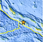
| Location | 8.270°S, 157.341°E |
| Depth | 4.1 km (2.5 miles) |
| Region | SOLOMON ISLANDS |
| Distances | 55 km (35 miles) ESE of Gizo, New Georgia Islands, Solomon Isl. 190 km (115 miles) W of Dadali, Santa Isabel, Solomon Islands 315 km (195 miles) WNW of HONIARA, Guadalcanal, Solomon Islands 2175 km (1350 miles) NNE of BRISBANE, Queensland, Australia |
| Location Uncertainty | horizontal +/- 28.3 km (17.6 miles); depth +/- 1 km (0.6 miles) |
| Parameters | NST= 16, Nph= 16, Dmin=315 km, Rmss=1.09 sec, Gp= 94°, M-type=body wave magnitude (Mb), Version=5 |
| Source |
|
| Event ID | usc00007k2 |
- Did you feel it? Report shaking and damage at your location. You can also view a map displaying accumulated data from your report and others.
Earthquake Maps


Scientific & Technical Information
 Historic Moment Tensor Solutions
- Preliminary Earthquake Report
- U.S. Geological Survey, National Earthquake Information Center:
World Data Center for Seismology, Denver
