
Magnitude 4.9 - SOUTH OF THE FIJI ISLANDS
2010 November 07 11:31:21 UTC
Earthquake Details
- This event has been reviewed by a seismologist.
| Magnitude | 4.9 |
|---|---|
| Date-Time |
|
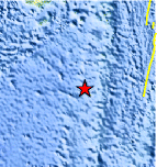
| Location | 22.320°S, 179.665°W |
| Depth | 622.5 km (386.8 miles) |
| Region | SOUTH OF THE FIJI ISLANDS |
| Distances | 210 km (130 miles) SSW of Ndoi Island, Fiji 480 km (300 miles) WSW of NUKU`ALOFA, Tonga 505 km (315 miles) SSE of SUVA, Viti Levu, Fiji 1695 km (1050 miles) NNE of Auckland, New Zealand |
| Location Uncertainty | horizontal +/- 22.6 km (14.0 miles); depth +/- 3.6 km (2.2 miles) |
| Parameters | NST=108, Nph=111, Dmin=559.9 km, Rmss=0.71 sec, Gp=122°, M-type=body wave magnitude (Mb), Version=7 |
| Source |
|
| Event ID | usc000077c |
- Did you feel it? Report shaking and damage at your location. You can also view a map displaying accumulated data from your report and others.
Earthquake Maps


Scientific & Technical Information
 Historic Moment Tensor Solutions
- Preliminary Earthquake Report
- U.S. Geological Survey, National Earthquake Information Center:
World Data Center for Seismology, Denver
