
Magnitude 4.6 - KEPULAUAN ARU REGION, INDONESIA
2010 November 06 05:09:17 UTC
Earthquake Details
- This event has been reviewed by a seismologist.
| Magnitude | 4.6 |
|---|---|
| Date-Time |
|
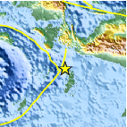
| Location | 5.341°S, 134.107°E |
| Depth | 35 km (21.7 miles) set by location program |
| Region | KEPULAUAN ARU REGION, INDONESIA |
| Distances | 50 km (30 miles) NNW of Dobo, Kepulauan Aru, Indonesia 295 km (185 miles) WSW of Enarotali, Papua, Indonesia 870 km (540 miles) NNE of DARWIN, Northern Territory, Australia 3015 km (1870 miles) E of JAKARTA, Java, Indonesia |
| Location Uncertainty | horizontal +/- 29.2 km (18.1 miles); depth fixed by location program |
| Parameters | NST= 23, Nph= 24, Dmin=426.4 km, Rmss=1.24 sec, Gp=169°, M-type=body wave magnitude (Mb), Version=7 |
| Source |
|
| Event ID | usc00006xj |
- Did you feel it? Report shaking and damage at your location. You can also view a map displaying accumulated data from your report and others.

Earthquake Maps


Scientific & Technical Information
 Historic Moment Tensor Solutions
- Preliminary Earthquake Report
- U.S. Geological Survey, National Earthquake Information Center:
World Data Center for Seismology, Denver
