
Magnitude 5.1 - SOLOMON ISLANDS
2010 October 28 00:53:28 UTC
Earthquake Details
- This event has been reviewed by a seismologist.
| Magnitude | 5.1 |
|---|---|
| Date-Time |
|
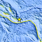
| Location | 10.767°S, 162.668°E |
| Depth | 45.3 km (28.1 miles) |
| Region | SOLOMON ISLANDS |
| Distances | 90 km (55 miles) ESE of Kira Kira, San Cristobal, Solomon Isl. 310 km (190 miles) SE of Auki, Malaita, Solomon Islands 330 km (205 miles) ESE of HONIARA, Guadalcanal, Solomon Islands 2115 km (1310 miles) NNE of BRISBANE, Queensland, Australia |
| Location Uncertainty | horizontal +/- 18.4 km (11.4 miles); depth +/- 2.3 km (1.4 miles) |
| Parameters | NST= 28, Nph= 29, Dmin=332.8 km, Rmss=1.24 sec, Gp= 65°, M-type=body wave magnitude (Mb), Version=7 |
| Source |
|
| Event ID | usc00004ap |
- Did you feel it? Report shaking and damage at your location. You can also view a map displaying accumulated data from your report and others.
Earthquake Maps


Scientific & Technical Information
 Historic Moment Tensor Solutions
 Tsunami Information
The earthquake locations and magnitudes cited in NOAA tsunami statements and bulletins are preliminary and are superseded by USGS locations and magnitudes computed using more extensive data sets.
NOAA Tsunami Bulletins for this Earthquake
No Bulletins have been issued at this time.
General Tsunami Information
- Preliminary Earthquake Report
- U.S. Geological Survey, National Earthquake Information Center:
World Data Center for Seismology, Denver
