
Magnitude 4.8 - PAPUA, INDONESIA
This webpage is being phased out and is no longer maintained. Please use the new Real-time Earthquake Map instead and update your bookmark. See Quick Tips & User Guide.
2013 January 23 17:05:17 UTC
Earthquake Details
- This event has been reviewed by a seismologist.
| Magnitude | 4.8 |
|---|---|
| Date-Time |
|
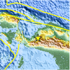
| Location | 3.394°S, 136.348°E |
| Depth | 48.2 km (30.0 miles) |
| Region | PAPUA, INDONESIA |
| Distances | 58 km (36 miles) N of Enarotali, Indonesia 96 km (59 miles) E of Nabire, Indonesia 376 km (233 miles) SE of Manokwari, Indonesia 472 km (293 miles) ENE of Tual, Indonesia |
| Location Uncertainty | horizontal +/- 21.9 km (13.6 miles); depth +/- 4.5 km (2.8 miles) |
| Parameters | NST= 40, Nph= 40, Dmin=458.6 km, Rmss=1.01 sec, Gp= 54°, M-type=body wave magnitude (Mb), Version=2 |
| Source |
|
| Event ID | usb000et9x |
- Did you feel it? Report shaking and damage at your location. You can also view a map displaying accumulated data from your report and others.

Earthquake Maps


Scientific & Technical Information
 Historic Moment Tensor Solutions
- Preliminary Earthquake Report
- U.S. Geological Survey, National Earthquake Information Center:
World Data Center for Seismology, Denver
