
Magnitude 4.8 - KEPULAUAN TANIMBAR REGION, INDONESIA
This webpage is being phased out and is no longer maintained. Please use the new Real-time Earthquake Map instead and update your bookmark. See Quick Tips & User Guide.
2013 January 18 05:16:15 UTC
Earthquake Details
- This event has been reviewed by a seismologist.
| Magnitude | 4.8 |
|---|---|
| Date-Time |
|
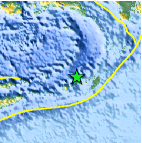
| Location | 7.316°S, 130.331°E |
| Depth | 89.4 km (55.6 miles) |
| Region | KEPULAUAN TANIMBAR REGION, INDONESIA |
| Distances | 129 km (80 miles) WNW of Saumlaki, Indonesia 324 km (201 miles) SW of Tual, Indonesia 466 km (289 miles) SSE of Ambon, Indonesia 467 km (290 miles) SSE of Amahai, Indonesia |
| Location Uncertainty | horizontal +/- 21.5 km (13.4 miles); depth +/- 13.4 km (8.3 miles) |
| Parameters | NST= 27, Nph= 32, Dmin=130.2 km, Rmss=1.53 sec, Gp=115°, M-type=body wave magnitude (Mb), Version=C |
| Source |
|
| Event ID | usb000equ4 |
- Did you feel it? Report shaking and damage at your location. You can also view a map displaying accumulated data from your report and others.

Earthquake Maps


Scientific & Technical Information
 Historic Moment Tensor Solutions
- Preliminary Earthquake Report
- U.S. Geological Survey, National Earthquake Information Center:
World Data Center for Seismology, Denver
