
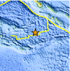
Magnitude 4.7 - D'ENTRECASTEAUX ISLANDS REGION
This webpage is being phased out and is no longer maintained. Please use the new Real-time Earthquake Map instead and update your bookmark. See Quick Tips & User Guide.
2013 January 16 11:23:02 UTC
Earthquake Details
- This event has been reviewed by a seismologist.
| Magnitude | 4.7 |
|---|---|
| Date-Time |
|
| Location | 9.679°S, 155.048°E |
| Depth | 10 km (6.2 miles) |
| Region | D'ENTRECASTEAUX ISLANDS REGION |
| Distances | 263 km (163 miles) SW of Gizo, Solomon Islands 387 km (240 miles) S of Arawa, Papua New Guinea 513 km (318 miles) E of Alotau, Papua New Guinea 538 km (334 miles) W of Honiara, Solomon Islands |
| Location Uncertainty | horizontal +/- 24.3 km (15.1 miles); depth +/- 4.4 km (2.7 miles) |
| Parameters | NST= 32, Nph= 32, Dmin=685.7 km, Rmss=0.3 sec, Gp= 86°, M-type=body wave magnitude (Mb), Version=5 |
| Source |
|
| Event ID | usb000epxg |
- Did you feel it? Report shaking and damage at your location. You can also view a map displaying accumulated data from your report and others.

Earthquake Maps


Scientific & Technical Information
 Historic Moment Tensor Solutions
- Preliminary Earthquake Report
- U.S. Geological Survey, National Earthquake Information Center:
World Data Center for Seismology, Denver
