
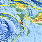
Magnitude 4.5 - NEAR THE SOUTH COAST OF PAPUA, INDONESIA
This webpage is being phased out and is no longer maintained. Please use the new Real-time Earthquake Map instead and update your bookmark. See Quick Tips & User Guide.
2013 January 15 12:07:35 UTC
Earthquake Details
- This event has been reviewed by a seismologist.
| Magnitude | 4.5 |
|---|---|
| Date-Time |
|
| Location | 4.312°S, 133.074°E |
| Depth | 17.6 km (10.9 miles) |
| Region | NEAR THE SOUTH COAST OF PAPUA, INDONESIA |
| Distances | 154 km (95 miles) NNE of Tual, Indonesia 287 km (178 miles) WSW of Nabire, Indonesia 397 km (246 miles) SSW of Manokwari, Indonesia 429 km (266 miles) SSE of Sorong, Indonesia |
| Location Uncertainty | horizontal +/- 18.9 km (11.7 miles); depth +/- 9.8 km (6.1 miles) |
| Parameters | NST= 35, Nph= 40, Dmin=179.2 km, Rmss=1.05 sec, Gp=155°, M-type=body wave magnitude (Mb), Version=5 |
| Source |
|
| Event ID | usb000ep9y |
- Did you feel it? Report shaking and damage at your location. You can also view a map displaying accumulated data from your report and others.

Earthquake Maps


Scientific & Technical Information
 Historic Moment Tensor Solutions
- Preliminary Earthquake Report
- U.S. Geological Survey, National Earthquake Information Center:
World Data Center for Seismology, Denver
