
Magnitude 4.7 - EAST OF THE NORTH ISLAND, NEW ZEALAND
This webpage is being phased out and is no longer maintained. Please use the new Real-time Earthquake Map instead and update your bookmark. See Quick Tips & User Guide.
2013 January 14 05:37:43 UTC
Earthquake Details
- This event has been reviewed by a seismologist.
| Magnitude | 4.7 |
|---|---|
| Date-Time |
|
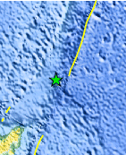
| Location | 35.217°S, 179.465°W |
| Depth | 72.4 km (45.0 miles) |
| Region | EAST OF THE NORTH ISLAND, NEW ZEALAND |
| Distances | 423 km (262 miles) S of L'Esperance Rock, New Zealand 439 km (272 miles) NE of Whakatane, New Zealand 442 km (274 miles) NNE of Gisborne, New Zealand 477 km (296 miles) NE of Tauranga, New Zealand |
| Location Uncertainty | horizontal +/- 85.6 km (53.2 miles); depth +/- 57.8 km (35.9 miles) |
| Parameters | NST= 43, Nph= 62, Dmin=328.4 km, Rmss=1.76 sec, Gp=223°, M-type=body wave magnitude (Mb), Version=6 |
| Source |
|
| Event ID | usb000enk5 |
- Did you feel it? Report shaking and damage at your location. You can also view a map displaying accumulated data from your report and others.
Earthquake Maps


Scientific & Technical Information
 Historic Moment Tensor Solutions
- Preliminary Earthquake Report
- U.S. Geological Survey, National Earthquake Information Center:
World Data Center for Seismology, Denver
