
Magnitude 3.4 - BASS STRAIT, AUSTRALIA
This webpage is being phased out and is no longer maintained. Please use the new Real-time Earthquake Map instead and update your bookmark. See Quick Tips & User Guide.
2013 January 12 20:21:18 UTC
Earthquake Details
- This event has been reviewed by a seismologist.
| Magnitude | 3.4 |
|---|---|
| Date-Time |
|
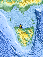
| Location | 40.833°S, 145.777°E |
| Depth | 9 km (5.6 miles) |
| Region | BASS STRAIT, AUSTRALIA |
| Distances | 19 km (11 miles) NNE of Wynyard, Australia 28 km (17 miles) NNW of Burnie, Australia 60 km (37 miles) NW of Devonport, Australia 135 km (83 miles) WNW of Launceston, Australia |
| Location Uncertainty | horizontal +/- 43.9 km (27.3 miles); depth +/- 6.3 km (3.9 miles) |
| Parameters | Nph= 0, Dmin=0 km, Rmss=0.51 sec, Gp= 0, M-type=local magnitude (ML), Version=5 |
| Source |
|
| Event ID | usb000en6t |
- Did you feel it? Report shaking and damage at your location. You can also view a map displaying accumulated data from your report and others.

Earthquake Maps


Scientific & Technical Information
- Preliminary Earthquake Report
- U.S. Geological Survey, National Earthquake Information Center:
World Data Center for Seismology, Denver
