
Magnitude 4.4 - SOUTH OF BALI, INDONESIA
This webpage is being phased out and is no longer maintained. Please use the new Real-time Earthquake Map instead and update your bookmark. See Quick Tips & User Guide.
2013 January 11 07:47:46 UTC
Earthquake Details
- This event has been reviewed by a seismologist.
| Magnitude | 4.4 |
|---|---|
| Date-Time |
|
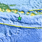
| Location | 9.502°S, 114.712°E |
| Depth | 75.6 km (47.0 miles) |
| Region | SOUTH OF BALI, INDONESIA |
| Distances | 86 km (53 miles) SSW of Kangin, Indonesia 99 km (61 miles) SSW of Kuta, Indonesia 109 km (67 miles) SSW of Denpasar, Indonesia 115 km (71 miles) SSW of Tabanan, Indonesia |
| Location Uncertainty | horizontal +/- 25.6 km (15.9 miles); depth +/- 4.3 km (2.7 miles) |
| Parameters | NST= 51, Nph= 52, Dmin=130.2 km, Rmss=0.75 sec, Gp=108°, M-type=body wave magnitude (Mb), Version=7 |
| Source |
|
| Event ID | usb000em7w |
- Did you feel it? Report shaking and damage at your location. You can also view a map displaying accumulated data from your report and others.

Earthquake Maps


Scientific & Technical Information
 Historic Moment Tensor Solutions
- Preliminary Earthquake Report
- U.S. Geological Survey, National Earthquake Information Center:
World Data Center for Seismology, Denver
