
Magnitude 4.6 - OFF WEST COAST OF THE NORTH ISLAND, N.Z.
This webpage is being phased out and is no longer maintained. Please use the new Real-time Earthquake Map instead and update your bookmark. See Quick Tips & User Guide.
2013 January 11 05:35:57 UTC
Earthquake Details
- This event has been reviewed by a seismologist.
| Magnitude | 4.6 |
|---|---|
| Date-Time |
|
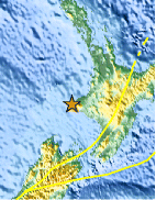
| Location | 39.310°S, 173.690°E |
| Depth | 11 km (6.8 miles) (poorly constrained) |
| Region | OFF WEST COAST OF THE NORTH ISLAND, N.Z. |
| Distances | 21 km (13 miles) NW of Opunake, New Zealand 43 km (26 miles) SW of New Plymouth, New Zealand 59 km (36 miles) WNW of Hawera, New Zealand 135 km (83 miles) WNW of Wanganui, New Zealand |
| Location Uncertainty | horizontal +/- 21.8 km (13.5 miles); depth +/- 12.7 km (7.9 miles) |
| Parameters | Nph= 0, Dmin=0 km, Rmss=1.43 sec, Gp= 0, M-type=local magnitude (ML), Version=9 |
| Source |
|
| Event ID | usb000em73 |
- Did you feel it? Report shaking and damage at your location. You can also view a map displaying accumulated data from your report and others.

Earthquake Maps


Scientific & Technical Information
 Historic Moment Tensor Solutions
Additional Information
- Preliminary Earthquake Report
- U.S. Geological Survey, National Earthquake Information Center:
World Data Center for Seismology, Denver
