
Magnitude 4.5 - PAPUA, INDONESIA
This webpage is being phased out and is no longer maintained. Please use the new Real-time Earthquake Map instead and update your bookmark. See Quick Tips & User Guide.
2012 November 06 17:30:10 UTC
Earthquake Details
- This event has been reviewed by a seismologist.
| Magnitude | 4.5 |
|---|---|
| Date-Time |
|
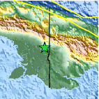
| Location | 5.858°S, 140.609°E |
| Depth | 86.5 km (53.8 miles) |
| Region | PAPUA, INDONESIA |
| Distances | 43 km (26 miles) NE of Tanahmerah, Indonesia 80 km (49 miles) WNW of Kiunga, Papua New Guinea 289 km (179 miles) N of Merauke, Indonesia 338 km (210 miles) W of Mendi, Papua New Guinea |
| Location Uncertainty | horizontal +/- 25 km (15.5 miles); depth +/- 11.6 km (7.2 miles) |
| Parameters | NST= 20, Nph= 22, Dmin=860.5 km, Rmss=0.69 sec, Gp= 90°, M-type=body wave magnitude (Mb), Version=6 |
| Source |
|
| Event ID | usb000dlbr |
- Did you feel it? Report shaking and damage at your location. You can also view a map displaying accumulated data from your report and others.

Earthquake Maps


Scientific & Technical Information
 Historic Moment Tensor Solutions
- Preliminary Earthquake Report
- U.S. Geological Survey, National Earthquake Information Center:
World Data Center for Seismology, Denver
