
Magnitude 4.6 - OFF THE WEST COAST OF NORTHERN SUMATRA
This webpage is being phased out and is no longer maintained. Please use the new Real-time Earthquake Map instead and update your bookmark. See Quick Tips & User Guide.
2012 November 06 09:25:19 UTC
Earthquake Details
- This event has been reviewed by a seismologist.
| Magnitude | 4.6 |
|---|---|
| Date-Time |
|
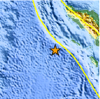
| Location | 1.928°N, 94.417°E |
| Depth | 10.1 km (6.3 miles) |
| Region | OFF THE WEST COAST OF NORTHERN SUMATRA |
| Distances | 226 km (140 miles) WSW of Sinabang, Indonesia 309 km (192 miles) SW of Meulaboh, Indonesia 413 km (256 miles) SSW of Banda Aceh, Indonesia 418 km (259 miles) SSW of Reuleuet, Indonesia |
| Location Uncertainty | horizontal +/- 23.2 km (14.4 miles); depth +/- 4.6 km (2.9 miles) |
| Parameters | NST= 34, Nph= 39, Dmin=358.4 km, Rmss=0.75 sec, Gp=108°, M-type=body wave magnitude (Mb), Version=6 |
| Source |
|
| Event ID | usb000dl4k |
- Did you feel it? Report shaking and damage at your location. You can also view a map displaying accumulated data from your report and others.
Earthquake Maps


Scientific & Technical Information
 Historic Moment Tensor Solutions
- Preliminary Earthquake Report
- U.S. Geological Survey, National Earthquake Information Center:
World Data Center for Seismology, Denver
