
Magnitude 4.1 - OFF EAST COAST OF THE NORTH ISLAND, N.Z.
This webpage is being phased out and is no longer maintained. Please use the new Real-time Earthquake Map instead and update your bookmark. See Quick Tips & User Guide.
2012 November 05 09:38:04 UTC
Earthquake Details
- This event has been reviewed by a seismologist.
| Magnitude | 4.1 |
|---|---|
| Date-Time |
|
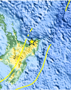
| Location | 37.830°S, 177.560°E |
| Depth | 42 km (26.1 miles) set by location program |
| Region | OFF EAST COAST OF THE NORTH ISLAND, N.Z. |
| Distances | 37 km (22 miles) NE of Opotiki, New Zealand 52 km (32 miles) ENE of Whakatane, New Zealand 99 km (61 miles) NNW of Gisborne, New Zealand 120 km (74 miles) ENE of Rotorua, New Zealand |
| Location Uncertainty | Error estimate not available |
| Parameters | Nph= 0, Dmin=0 km, Rmss=0 sec, Gp= 0, M-type=local magnitude (ML), Version=8 |
| Source |
|
| Event ID | usb000dkhv |
- Did you feel it? Report shaking and damage at your location. You can also view a map displaying accumulated data from your report and others.

Earthquake Maps


Scientific & Technical Information
 Historic Moment Tensor Solutions
Additional Information
- Preliminary Earthquake Report
- U.S. Geological Survey, National Earthquake Information Center:
World Data Center for Seismology, Denver
