
Magnitude 4.9 - VANUATU
This webpage is being phased out and is no longer maintained. Please use the new Real-time Earthquake Map instead and update your bookmark. See Quick Tips & User Guide.
2012 November 04 00:16:33 UTC
Earthquake Details
- This event has been reviewed by a seismologist.
| Magnitude | 4.9 |
|---|---|
| Date-Time |
|
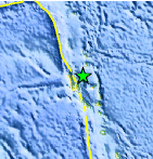
| Location | 14.857°S, 167.316°E |
| Depth | 147.4 km (91.6 miles) |
| Region | VANUATU |
| Distances | 35 km (21 miles) NE of Port-Olry, Vanuatu 76 km (47 miles) NNE of Luganville, Vanuatu 335 km (208 miles) NNW of Port-Vila, Vanuatu 670 km (416 miles) N of We, New Caledonia |
| Location Uncertainty | horizontal +/- 20.1 km (12.5 miles); depth +/- 9 km (5.6 miles) |
| Parameters | NST= 46, Nph= 48, Dmin=803.7 km, Rmss=0.63 sec, Gp=101°, M-type=body wave magnitude (Mb), Version=6 |
| Source |
|
| Event ID | usb000dk11 |
- Did you feel it? Report shaking and damage at your location. You can also view a map displaying accumulated data from your report and others.
Earthquake Maps


Scientific & Technical Information
 Historic Moment Tensor Solutions
- Preliminary Earthquake Report
- U.S. Geological Survey, National Earthquake Information Center:
World Data Center for Seismology, Denver
