
Magnitude 4.9 - FIJI REGION
This webpage is being phased out and is no longer maintained. Please use the new Real-time Earthquake Map instead and update your bookmark. See Quick Tips & User Guide.
2012 November 03 20:49:11 UTC
Earthquake Details
- This event has been reviewed by a seismologist.
| Magnitude | 4.9 |
|---|---|
| Date-Time |
|
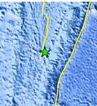
| Location | 21.933°S, 176.317°W |
| Depth | 105.5 km (65.6 miles) |
| Region | FIJI REGION |
| Distances | 141 km (87 miles) SW of Vaini, Tonga 145 km (90 miles) SW of Nuku`alofa, Tonga 689 km (428 miles) SE of Suva, Fiji 759 km (471 miles) SE of Lambasa, Fiji |
| Location Uncertainty | horizontal +/- 21 km (13.0 miles); depth +/- 8 km (5.0 miles) |
| Parameters | NST= 97, Nph= 98, Dmin=826 km, Rmss=0.85 sec, Gp= 47°, M-type=body wave magnitude (Mb), Version=5 |
| Source |
|
| Event ID | usb000djzq |
- Did you feel it? Report shaking and damage at your location. You can also view a map displaying accumulated data from your report and others.
Earthquake Maps


Scientific & Technical Information
 Historic Moment Tensor Solutions
 Tsunami Information
The earthquake locations and magnitudes cited in NOAA tsunami statements and bulletins are preliminary and are superseded by USGS locations and magnitudes computed using more extensive data sets.
General Tsunami Information
- Preliminary Earthquake Report
- U.S. Geological Survey, National Earthquake Information Center:
World Data Center for Seismology, Denver
