
Magnitude 6.1 - MINDANAO, PHILIPPINES
This webpage is being phased out and is no longer maintained. Please use the new Real-time Earthquake Map instead and update your bookmark. See Quick Tips & User Guide.
2012 November 02 18:17:33 UTC
Earthquake Details
- This event has been reviewed by a seismologist.
| Magnitude | 6.1 |
|---|---|
| Date-Time |
|
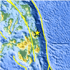
| Location | 9.259°N, 126.233°E |
| Depth | 38.1 km (23.7 miles) |
| Region | MINDANAO, PHILIPPINES |
| Distances | 7 km (4 miles) ESE of Burgos, Philippines 18 km (11 miles) NNE of Tandag, Philippines 69 km (42 miles) NNE of Lianga, Philippines 75 km (46 miles) NE of Bayugan, Philippines |
| Location Uncertainty | horizontal +/- 12.2 km (7.6 miles); depth +/- 2.8 km (1.7 miles) |
| Parameters | NST=510, Nph=541, Dmin=252.7 km, Rmss=1.11 sec, Gp= 11°, M-type=(unknown type), Version=E |
| Source |
|
| Event ID | usb000djgv |
- Did you feel it? Report shaking and damage at your location. You can also view a map displaying accumulated data from your report and others.

Earthquake Maps


- Preliminary Earthquake Report
- U.S. Geological Survey, National Earthquake Information Center:
World Data Center for Seismology, Denver
