
Magnitude 5.2 - NEAR THE SOUTHEAST COAST OF AUSTRALIA
This webpage has been replaced by a new version and will be phased out in the future. Please use our new Real-time Earthquake Map to access the latest earthquake information and event details. The links to the World, US, and CA/NV maps that were in the navigation on the left side of the page have been replaced by the links at the top of the new Map. The Real-time Earthquake Map User Guide describes how to use the map and all its features.
2012 June 19 10:53:29 UTC
Earthquake Details
- This event has been reviewed by a seismologist.
| Magnitude | 5.2 |
|---|---|
| Date-Time |
|
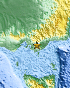
| Location | 38.244°S, 146.194°E |
| Depth | 9.9 km (6.2 miles) |
| Region | NEAR THE SOUTHEAST COAST OF AUSTRALIA |
| Distances | 10 km (6 miles) SW of Moe, Australia 18 km (11 miles) W of Morwell, Australia 30 km (18 miles) WSW of Traralgon, Australia 78 km (48 miles) WSW of Sale, Australia |
| Location Uncertainty | horizontal +/- 15.2 km (9.4 miles); depth +/- 2.9 km (1.8 miles) |
| Parameters | NST= 44, Nph= 49, Dmin=410.8 km, Rmss=1.12 sec, Gp= 68°, M-type=body wave magnitude (Mb), Version=5 |
| Source |
|
| Event ID | usb000ajek |
- Did you feel it? Report shaking and damage at your location. You can also view a map displaying accumulated data from your report and others.

Earthquake Maps


Scientific & Technical Information
- Preliminary Earthquake Report
- U.S. Geological Survey, National Earthquake Information Center:
World Data Center for Seismology, Denver
