
Magnitude 4.8 - SOUTH ISLAND OF NEW ZEALAND
This webpage has been replaced by a new version and will be phased out in the future. Please use our new Real-time Earthquake Map to access the latest earthquake information and event details. The links to the World, US, and CA/NV maps that were in the navigation on the left side of the page have been replaced by the links at the top of the new Map. The Real-time Earthquake Map User Guide describes how to use the map and all its features.
2012 May 20 05:06:56 UTC
Earthquake Details
- This event has been reviewed by a seismologist.
| Magnitude | 4.8 |
|---|---|
| Date-Time |
|
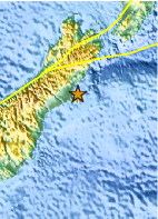
| Location | 43.573°S, 172.932°E |
| Depth | 10.2 km (6.3 miles) |
| Region | SOUTH ISLAND OF NEW ZEALAND |
| Distances | 21 km (13 miles) E of Christchurch, New Zealand 229 km (142 miles) SSE of Westport, New Zealand 294 km (182 miles) SSW of WELLINGTON, New Zealand 320 km (198 miles) NE of Dunedin, New Zealand |
| Location Uncertainty | horizontal +/- 13.3 km (8.3 miles); depth +/- 4.7 km (2.9 miles) |
| Parameters | NST= 23, Nph= 28, Dmin=24.5 km, Rmss=0.58 sec, Gp=187°, M-type=local magnitude (ML), Version=5 |
| Source |
|
| Event ID | usb0009tla |
- Did you feel it? Report shaking and damage at your location. You can also view a map displaying accumulated data from your report and others.

Earthquake Maps


Scientific & Technical Information
 Historic Moment Tensor Solutions
Additional Information
- Preliminary Earthquake Report
- U.S. Geological Survey, National Earthquake Information Center:
World Data Center for Seismology, Denver
