
Magnitude 4.1 - FIJI REGION
This webpage has been replaced by a new version and will be phased out in the future. Please use our new Real-time Earthquake Map to access the latest earthquake information and event details. The links to the World, US, and CA/NV maps that were in the navigation on the left side of the page have been replaced by the links at the top of the new Map. The Real-time Earthquake Map User Guide describes how to use the map and all its features.
2012 May 19 02:48:00 UTC
Earthquake Details
- This event has been reviewed by a seismologist.
| Magnitude | 4.1 |
|---|---|
| Date-Time |
|
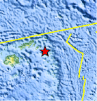
| Location | 17.151°S, 179.287°W |
| Depth | 553 km (343.6 miles) |
| Region | FIJI REGION |
| Distances | 163 km (101 miles) ESE of Lambasa, Vanua Levu, Fiji 266 km (165 miles) ENE of SUVA, Viti Levu, Fiji 337 km (209 miles) SSW of Sigave, Ile Futuna, Wallis and Futuna 2262 km (1405 miles) NNE of Auckland, New Zealand |
| Location Uncertainty | horizontal +/- 44.8 km (27.8 miles); depth +/- 13 km (8.1 miles) |
| Parameters | NST= 51, Nph= 51, Dmin=290.5 km, Rmss=0.68 sec, Gp=166°, M-type=body wave magnitude (Mb), Version=4 |
| Source |
|
| Event ID | usb0009t98 |
- Did you feel it? Report shaking and damage at your location. You can also view a map displaying accumulated data from your report and others.
Earthquake Maps


Scientific & Technical Information
 Historic Moment Tensor Solutions
- Preliminary Earthquake Report
- U.S. Geological Survey, National Earthquake Information Center:
World Data Center for Seismology, Denver
