
Magnitude 4.8 - KEPULAUAN BABAR, INDONESIA
This webpage has been replaced by a new version and will be phased out in the future. Please use our new Real-time Earthquake Map to access the latest earthquake information and event details. The links to the World, US, and CA/NV maps that were in the navigation on the left side of the page have been replaced by the links at the top of the new Map. The Real-time Earthquake Map User Guide describes how to use the map and all its features.
2012 May 13 23:10:31 UTC
Earthquake Details
- This event has been reviewed by a seismologist.
| Magnitude | 4.8 |
|---|---|
| Date-Time |
|
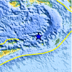
| Location | 7.077°S, 129.291°E |
| Depth | 162.5 km (101.0 miles) |
| Region | KEPULAUAN BABAR, INDONESIA |
| Distances | 243 km (150 miles) WNW of Saumlaki, Kepulauan Tanimbar, Indonesia 393 km (244 miles) SSE of Ambon, Moluccas, Indonesia 441 km (274 miles) ENE of DILI, Timor-Leste 619 km (384 miles) NNW of DARWIN, Northern Territory, Australia |
| Location Uncertainty | horizontal +/- 29.6 km (18.4 miles); depth +/- 15.4 km (9.6 miles) |
| Parameters | NST= 19, Nph= 20, Dmin=242.7 km, Rmss=1.17 sec, Gp=104°, M-type=body wave magnitude (Mb), Version=4 |
| Source |
|
| Event ID | usb0009p70 |
- Did you feel it? Report shaking and damage at your location. You can also view a map displaying accumulated data from your report and others.

Earthquake Maps


Scientific & Technical Information
 Historic Moment Tensor Solutions
- Preliminary Earthquake Report
- U.S. Geological Survey, National Earthquake Information Center:
World Data Center for Seismology, Denver
