
Magnitude 4.6 - PAPUA, INDONESIA
This webpage has been replaced by a new version and will be phased out in the future. Please use our new Real-time Earthquake Map to access the latest earthquake information and event details. The links to the World, US, and CA/NV maps that were in the navigation on the left side of the page have been replaced by the links at the top of the new Map. The Real-time Earthquake Map User Guide describes how to use the map and all its features.
2012 May 13 02:35:35 UTC
Earthquake Details
- This event has been reviewed by a seismologist.
| Magnitude | 4.6 |
|---|---|
| Date-Time |
|
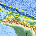
| Location | 2.681°S, 138.800°E |
| Depth | 35 km (21.7 miles) |
| Region | PAPUA, INDONESIA |
| Distances | 211 km (131 miles) W of Jayapura, Papua, Indonesia 274 km (170 miles) W of Vanimo, New Guinea, PNG 1394 km (866 miles) NE of DARWIN, Northern Territory, Australia 3569 km (2217 miles) E of JAKARTA, Java, Indonesia |
| Location Uncertainty | horizontal +/- 29.5 km (18.3 miles); depth +/- 8.3 km (5.2 miles) |
| Parameters | NST= 21, Nph= 21, Dmin=729.1 km, Rmss=0.8 sec, Gp=104°, M-type=body wave magnitude (Mb), Version=5 |
| Source |
|
| Event ID | usb0009ntd |
- Did you feel it? Report shaking and damage at your location. You can also view a map displaying accumulated data from your report and others.

Earthquake Maps


Scientific & Technical Information
 Historic Moment Tensor Solutions
- Preliminary Earthquake Report
- U.S. Geological Survey, National Earthquake Information Center:
World Data Center for Seismology, Denver
