
Magnitude 4.5 - FLORES REGION, INDONESIA
This webpage has been replaced by a new version and will be phased out in the future. Please use our new Real-time Earthquake Map to access the latest earthquake information and event details. The links to the World, US, and CA/NV maps that were in the navigation on the left side of the page have been replaced by the links at the top of the new Map. The Real-time Earthquake Map User Guide describes how to use the map and all its features.
2012 May 11 23:05:41 UTC
Earthquake Details
- This event has been reviewed by a seismologist.
| Magnitude | 4.5 |
|---|---|
| Date-Time |
|
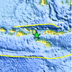
| Location | 8.946°S, 119.083°E |
| Depth | 123 km (76.4 miles) |
| Region | FLORES REGION, INDONESIA |
| Distances | 67 km (41 miles) SE of Bima, Sumbawa, Indonesia 151 km (93 miles) WNW of Waingapu, Sumba, Indonesia 282 km (175 miles) W of Ende, Flores, Indonesia 715 km (444 miles) W of DILI, Timor-Leste |
| Location Uncertainty | horizontal +/- 26.4 km (16.4 miles); depth +/- 11.7 km (7.3 miles) |
| Parameters | NST= 32, Nph= 34, Dmin=348.4 km, Rmss=0.99 sec, Gp= 97°, M-type=body wave magnitude (Mb), Version=5 |
| Source |
|
| Event ID | usb0009nga |
- Did you feel it? Report shaking and damage at your location. You can also view a map displaying accumulated data from your report and others.

Earthquake Maps


Scientific & Technical Information
 Historic Moment Tensor Solutions
- Preliminary Earthquake Report
- U.S. Geological Survey, National Earthquake Information Center:
World Data Center for Seismology, Denver
