
Magnitude 4.3 - BANDA SEA
This webpage has been replaced by a new version and will be phased out in the future. Please use our new Real-time Earthquake Map to access the latest earthquake information and event details. The links to the World, US, and CA/NV maps that were in the navigation on the left side of the page have been replaced by the links at the top of the new Map. The Real-time Earthquake Map User Guide describes how to use the map and all its features.
2012 May 10 23:45:44 UTC
Earthquake Details
- This event has been reviewed by a seismologist.
| Magnitude | 4.3 |
|---|---|
| Date-Time |
|
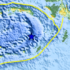
| Location | 6.218°S, 130.557°E |
| Depth | 150.7 km (93.6 miles) |
| Region | BANDA SEA |
| Distances | 208 km (129 miles) NNW of Saumlaki, Kepulauan Tanimbar, Indonesia 384 km (238 miles) SE of Ambon, Moluccas, Indonesia 608 km (377 miles) ENE of DILI, Timor-Leste 692 km (429 miles) N of DARWIN, Northern Territory, Australia |
| Location Uncertainty | horizontal +/- 20.4 km (12.7 miles); depth +/- 21.1 km (13.1 miles) |
| Parameters | NST= 19, Nph= 20, Dmin=211.5 km, Rmss=1.06 sec, Gp= 79°, M-type=body wave magnitude (Mb), Version=3 |
| Source |
|
| Event ID | usb0009mi0 |
- Did you feel it? Report shaking and damage at your location. You can also view a map displaying accumulated data from your report and others.

Earthquake Maps


Scientific & Technical Information
 Historic Moment Tensor Solutions
- Preliminary Earthquake Report
- U.S. Geological Survey, National Earthquake Information Center:
World Data Center for Seismology, Denver
